Property Record
149 Oneta St, Athens, GA 30601

NEARBY LISTINGS FOR SALE OR LEASE
-
-
View all Athens listings for lease on LoopNet.com
Property Detail
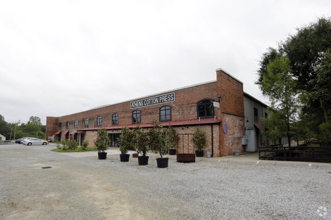
149 Oneta St
114B1-B-006-C
Com-Sf-020
Commercialnec
UNIT 6B-2 PH. 2 - CHASE ST PARK CONDOMINIUMS
X
Clarke
13059C0015E
Georgia
2025
0.25 AC
2025
North Athens
130300
Other Market Areas
9,852 SF
Athens-Clarke County, GA
DEMOGRAPHICS near 149 Oneta St
1 Mile
3 Mile
5 Mile
2024 Total Population
7,033
62,538
111,521
2029 Population
7,064
62,683
112,035
Pop Growth 2024-2029
+ 0.44%
+ 0.23%
+ 0.46%
Average Age
32
33
34
2024 Total Households
3,041
23,476
44,033
HH Growth 2024-2029
+ 0.46%
+ 0.20%
+ 0.44%
Median Household Inc
$46,460
$44,817
$48,057
Avg Household Size
2.10
2.20
2.20
2024 Avg HH Vehicles
2.00
2.00
2.00
Median Home Value
$373,170
$275,231
$253,651
Median Year Built
1973
1978
1985
Nearby Places
Map Layers
Map Styles
 Street
 Aerial
- Restaurants
- Banks
- Shops
- Fitness
- Groceries
SALE & LEASE HISTORY
LISTING DATE
SALE/LEASE

Sep 25, 2016
For Lease
Oct 31, 2017
For Lease
Nearby Properties
Address
Land Use
TOTAL SIZE
Lot Size
Zoning
Address
Land Use
TOTAL SIZE
Lot Size
Zoning
11.36 AC
G
Address
Land Use
TOTAL SIZE
Lot Size
Zoning
33.61 AC
G
Address
Land Use
TOTAL SIZE
Lot Size
Zoning
81,812 SF
6.23 AC
C-D (RIV)
Address
Land Use
TOTAL SIZE
Lot Size
Zoning
21.57 AC
G
Address
Land Use
TOTAL SIZE
Lot Size
Zoning
49.33 AC
G
Address
Land Use
TOTAL SIZE
Lot Size
Zoning
35 AC
G
Address
Land Use
TOTAL SIZE
Lot Size
Zoning
17.90 AC
G
Address
Land Use
TOTAL SIZE
Lot Size
Zoning
24.70 AC
G
Address
Land Use
TOTAL SIZE
Lot Size
Zoning
47.56 AC
G
Address
Land Use
TOTAL SIZE
Lot Size
Zoning
163,904 SF
3.75 AC
C-D
Address
Land Use
TOTAL SIZE
Lot Size
Zoning
10,240 SF
6.47 AC
G
Address
Land Use
TOTAL SIZE
Lot Size
Zoning
16.60 AC
G
Address
Land Use
TOTAL SIZE
Lot Size
Zoning
21.64 AC
G
Address
Land Use
TOTAL SIZE
Lot Size
Zoning
122,400 SF
12.51 AC
G
Address
Land Use
TOTAL SIZE
Lot Size
Zoning
85,608 SF
63.75 AC
RM-2
Address
Land Use
TOTAL SIZE
Lot Size
Zoning
21.04 AC
G
Address
Land Use
TOTAL SIZE
Lot Size
Zoning
8.38 AC
G
Address
Land Use
TOTAL SIZE
Lot Size
Zoning
213,612 SF
3.07 AC
C-D
Address
Land Use
TOTAL SIZE
Lot Size
Zoning
184,293 SF
1.84 AC
C-D
Address
Land Use
TOTAL SIZE
Lot Size
Zoning
56.15 AC
G
Address
Land Use
TOTAL SIZE
Lot Size
Zoning
226,339 SF
2.32 AC
C-D (RIV)
Address
Land Use
TOTAL SIZE
Lot Size
Zoning
36.88 AC
G
Address
Land Use
TOTAL SIZE
Lot Size
Zoning
20 AC
G
Address
Land Use
TOTAL SIZE
Lot Size
Zoning
17.23 AC
G
Address
Land Use
TOTAL SIZE
Lot Size
Zoning
6.15 AC
G
Address
Land Use
TOTAL SIZE
Lot Size
Zoning
97,317 SF
24.31 AC
C-G
Address
Land Use
TOTAL SIZE
Lot Size
Zoning
81,973 SF
4.97 AC
G
Address
Land Use
TOTAL SIZE
Lot Size
Zoning
5,501 SF
1.47 AC
C-D
Address
Land Use
TOTAL SIZE
Lot Size
Zoning
265,400 SF
2.95 AC
C-D
Address
Land Use
TOTAL SIZE
Lot Size
Zoning
15.29 AC
G
The World's #1 Commercial Real Estate Marketplace
Connect with us
© 2025 CoStar Group
The information above has been obtained from sources believed reliable. While we do not doubt its accuracy we have not verified it and make no guarantee, warranty or representation about it. It is your responsibility to independently confirm its accuracy and completeness. Any projections, opinions, assumptions, or estimates used are for example only and do not represent the current or future performance of the property. The value of this transaction to you depends on tax and other factors which should be evaluated by your tax, financial, and legal advisors. You and your advisors should conduct a careful, independent investigation of the property to determine to your satisfaction the suitability of the property for your needs.